One of Sacramento history’s best-hidden stories is the tale of our city’s missing sibling: During the Gold Rush, a site called Boston lay just north of the American River’s confluence with the Sacramento River – then located roughly at the new Railyards Boulevard. Boston appears to have been founded around the same time as Sacramento City, and at least two surviving maps show the two urban grids as being comparable in size and substance – and both much larger than anything else in the area.
However, while Sacramento City grew rapidly and matured into a major metropolis, Boston was soon abandoned. During the 1860s, its land was divided by the northward rerouting of the American River. Afterwards, Boston’s southern portion was gradually absorbed into what became Sacramento’s industrial zone, while its northern reaches remained largely undeveloped until much of it became parkland a century later.
Boston was apparently a “paper city” that existed primarily to fleece investors unfortunate enough to buy land amongst the shifting channels at the confluence of two major rivers. Its most visible footprint can be found on an 1850 navigational chart by Cadwalader Ringgold. It turns out that Ringgold was also Boston’s surveyor, so he had a conflict of interest in depicting the place as a competitor to Sacramento City. Ringgold went on to great success in Sacramento speculation, buying and selling large tracts of land. On the other hand, little or nothing seems to have been built along Boston’s streets.
Boston was perhaps a better site than the one that grew in the swamplands between Johann Sutter’s embarcadero and fort (despite his objections and his lack of legitimate title). Boston certainly could not have been any worse a site than Sacramento City, which sprawled across the wetlands south of the American River. Boston’s location actually provided a better connection between the navigable Sacramento River and overland routes from the East and to the mines.
But Boston was not just a better location in the abstract – a close inspection of modern property lines reveals that the lost history of Boston echoes to the present day. Its absence explains gaps in Sacramento’s eventual development, and is in turn explained by the false revisionist history that we accept as true.
The Missing City
The failure of Boston helps to explain the large urban wilderness that is now Discovery Park, located on high ground that once included the central Nisenan village of Pujune. We would expect this area to have developed in ways similar to what is found downtown or in West Sacramento.
During the Gold Rush, the Sacramento area was the heart of a volatile economic and social system – and a relatively stable landing spot for one of the most dramatic movements of human beings in world history. We can understand that movement better if we look beyond the successful settlements and examine the schemes that didn’t quite make it.
Boston was – like Sacramento City and Washington (now West Sacramento) – one of a trio of settlements perched on the points where two key rivers came together. This urban triplet was the heart of California’s economy, a primary distribution center for goods flowing from San Francisco to a constantly shifting network of settlements formed in pursuit of the latest cry of “Gold!”
The confluence was home to one of very few persistent settlements of fortune-seekers. Here, one could get rich selling just about anything to those who chased after the latest strike, and who could build or abandon a town of thousands in days. Given the ongoing value of land around the confluence, it does not make sense that there would be no settlement north of the “American Fork” that flowed in from the Sierra Nevada.
At Boston, those arriving from the East or headed back to the northern mines would have avoided the final additional crossing of the American River, which faced those passing through Sacramento City. Later, the Boston site would have been a better terminus for the transcontinental railroad, and then for additional railways that reached the San Francisco Bay. Indeed some remnants of Boston connect to the railyards that were eventually built in the decades after the land scheme’s collapse.
And as land routes developed, crossings of the Sacramento River would have been easier upstream of the added flow from its volatile tributary. Boston was an obvious place for a city, and yet nothing seems to have developed there.
The Lost City’s Boundaries
Boston’s layout was described in Edward Gould Buffum’s Six Months in the Gold Mines (1850), which depicted it as a viable planned town,
with large public squares, and reservations for school-houses, churches, and public buildings. One of the peculiar advantages of Boston is that, being located on the northern bank of the American Fork, it is not necessary in proceeding to the gold mines to cross that river, which is exceedingly high and rapid at some seasons of the year…Lots are selling rapidly at from $200 to $1000 each and before many months, the city of Boston on the golden banks of the Rio Sacramento will rival its New England namesake in business and importance.
His prediction proved wildly optimistic – perhaps because the lots closest to the confluence were on low and flood-prone land.
However, Buffum offered a key clue that allows reconstruction of Boston’s footprint: He described its grid as being made up of blocks measuring 240 by 320 feet, which matches the rectangular pattern in Ringgold’s chart inset – of “the cities of Sacramento and Boston” – depicting a large city encompassing more than 100 city blocks stretching more than a mile up both rivers.
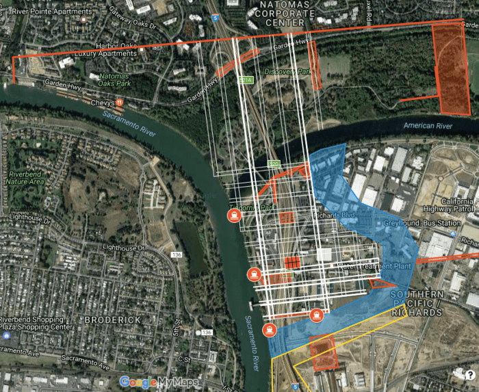
To illustrate Boston’s large expanse Confluence has produced an interactive map showing a grid of the planned streets of Boston superimposed on today’s city. Crucially, this old grid lines up with a small but significant number of modern features. This alignment suggests that the parcels originally created for Boston survived in some form, and that a portion of this paper city survived up to the present day:
- A new roadway at the edge of the Railyards redevelopment seems to be an unintentional reconstruction of what was once Boston’s southernmost intersections.
- The old PG&E power plant lies on a set of parcels that closely matches Boston’s grid, taking up most of two old city blocks.
- The former Rusty Duck parking lot may have once been a waterfront street facing the long-lost curve in the American River.
None of this is conclusive evidence that Boston ever got beyond its initial land sales by Ringgold and his partners. I’ve so far found no evidence that Sacramento City’s lost sibling ever existed as a functional community. Yet there are hints that this was not merely the fault of Boston’s residents – perhaps Sacramento City’s promoters actively killed off this competing town, leaving only scattered legal traces.
The Road to Oblivion
Although the Boston survey left numerous marks on the legal landscape north of the American River, this failed scheme strangely never seems to have been a topic of conversation among its southern neighbors; Boston was rarely – if ever – mentioned in Sacramento City newspapers of the early 1850s.
Whether Boston was merely a paper town that existed to cheat settlers and speculators, or whether it struggled for a while before collapsing, there seems to have been a general understanding that Boston was not part of Sacramento’s history.
There may yet be undiscovered references to Boston. Over the years, a huge number of real estate transactions, lawsuits and other exchanges have no doubt taken place on land that was once Boston; any one of these stories might have prompted someone to do a little historical research. Unfortunately, such references are so many needles in a haystack. “Boston” is a particularly challenging term for digital searches, as the vast majority of returns are in reference to the city in Massachusetts.
Perhaps Boston just wasn’t very interesting, but that seems unlikely. Its site appears in the 1854 map of Sacramento City as a rough area of waterways, trees and rocks. A similar depiction appeared in the 1873 Gray’s Atlas map. These maps both seem designed to convince people that there was no such town, which would have been unnecessary if there actually had been no such town.
Whatever the details of its demise, it is now clear that Boston was more than just marks on a map. Although much remains unclear, Boston now joins the gallery of gaps in Sacramento’s history. It is yet another missing link in the broken chain connecting us to our origins as a city of struggle between settlers and speculators.
Who Killed Boston?
There must have been people wanting to settle on the land occupied by Boston, but something prevented the founding of a sustainable community. The Boston land offering may have been a scam selling junk land, doomed to failure. But it is simply not plausible that nobody ever wanted to live on the northern bank of the lower American River.
It is certainly possible that Boston failed due to simple mismanagement. Perhaps its landowners were simply unable to come up with a coherent system of governance that was needed to address the urgent threat of flooding. Perhaps the infant town was simply wiped out by the flood of 1850, which also inundated even the highest parts of Sacramento City.
In any case, we might expect the success or failure of a neighboring town to be of interest to early Sacramentans, who faced similar challenges. At the very least, there should have been warnings to avoid buying land in Boston, and reports of its hapless victims’ suffering. Yet the (surviving copies of) newspapers were apparently silent on the fate of Sacramento City’s northern twin.
The absence of any early settlement at Boston’s excellent location suggests that development was impeded by something. The relative absence of stories about Boston’s failure suggests that development was impeded by someone.
Who would do such a thing? And why?
Things are not as they seem in the River City, and Boston is only one of several lost communities. Nowadays, the Sacramento area’s original Indigenous and European settlement sites – including a pair of modest street systems at key crossings of the American River – are largely abandoned wastelands. Meanwhile, Sutter’s preferred urban site downstream of Sacramento City is today an indistinct expanse of suburban development, with only faint traces of that failed city’s old grid.
The quiet burial of Boston seems to be part of a larger project of historical suppression, which was concocted over decades to enrich and then redeem the crooked speculators who built the city across the American River. This same project has provided Sacramento with a scrambled narrative full of deeply flawed maps, villains made into heroes and heroes made into fools.
Setting the record straight is a key part of the mission of Confluence Tours, and the recovery of Boston’s history will be an ongoing part of the effort.

[…] of the American River during the Gold Rush. This appears to confirm elements of a Confluence report published in June, most notably that the site of Boston was an important crossroads if not a suitable […]
LikeLike